IMAGES TAKEN NEAR TO
Old Wern Road, SWANSEA, SA9 2LL
Introduction
This page details the photographs taken nearby to Old Wern Road, SA9 2LL by members of the Geograph project.
The Geograph project started in 2005 with the aim of publishing, organising and preserving representative images for every square kilometre of Great Britain, Ireland and the Isle of Man.

There are currently over 7.5m images from over14,400 individuals and you can help contribute to the project by visiting https://www.geograph.org.uk
Image Map
Images are licensed for reuse under creativecommons.org/licenses/by-sa/2.0
Notes
- Clicking on the map will re-center to the selected point.
- The higher the marker number, the further away the image location is from the centre of the postcode.
Image Listing (19 Images Found)
Images are licensed for reuse under creativecommons.org/licenses/by-sa/2.0
Image
Details
Distance
1
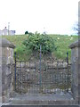
Gates to English Congregational Church
The English Congregational Church was built in 1869. Foundation stone laid by H O Wills Esq of Bristol (of cigarette fame). In 2005 due to subsidence it was pulled down. The Spire was an Ordnance Survey Triangulation Station (SN80/INT031).
Image: © Adrian Dust
Taken: 31 Mar 2012
0.07 miles
2
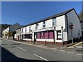
Commercial Street
Shops in Commercial Street, Ystalyfera.
Image: © Alan Hughes
Taken: 26 Mar 2020
0.12 miles
4
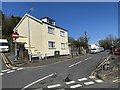
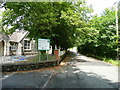
Tirbach Road
House on Tirbach Road, Ystalyfera. The road leads to the site of a disused colliery.
Image: © Alan Hughes
Taken: 26 Mar 2020
0.14 miles
5
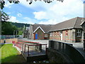
Ysgol Gyfun Ystalyfera
A Welsh-medium community comprehensive school for 11 to 18 year-olds.
Image: © Jonathan Billinger
Taken: 8 Aug 2008
0.15 miles
6
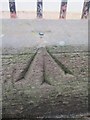
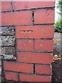
Ordnance Survey Rivet
This OS rivet can be found on the wall of Capel Y Wern. It marks a point 96.338m above mean sea level. http://www.geograph.org.uk/photo/3601192
Image: © Adrian Dust
Taken: 15 Aug 2013
0.16 miles
7
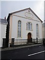
Capel Y Wern
There is an OS rivet with arrow on the wall of the chapel. http://www.geograph.org.uk/photo/3601185
Image: © Adrian Dust
Taken: 15 Aug 2013
0.16 miles
8
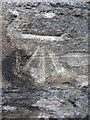
Ordnance Survey Cut Mark
This OS cut mark can be found on the school wall on School Rd. It marks a point 115.041m above mean sea level.
Image: © Adrian Dust
Taken: 15 Aug 2013
0.19 miles
9
Glan Yr Afon, Ystalyfera
By the main entrance to Ysgol Gyfun, Ystalyfera, looking north.
Image: © Jonathan Billinger
Taken: 8 Aug 2008
0.19 miles
10
Ordnance Survey Cut Mark
This OS cut mark can be found on the corner of the school. It marks a point 64.487m above mean sea level.
Image: © Adrian Dust
Taken: 15 Aug 2013
0.19 miles